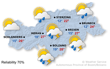
Weather
Last update: 21.07.2026, 11:00
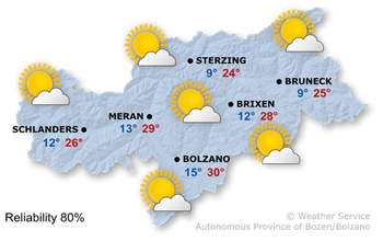
Weather today
The high-pressure system will weaken temporarily, and a weather system will cross the alpine region from the west as the day progresses.
South Tyrol will see periods of sunshine. As the day progresses, a few showers will move in from the west, with the possibility of isolated thunderstorms. A northerly wind will develop in many valleys.
Temperatures will reach highs of between 22° and 28°.
Weather tomorrow
High air pressure, combined with a northerly upper-level flow, is bringing stable, summer-like conditions.
On Wednesday, sunshine will be widespread, with only a few harmless clouds in the sky.
Temperatures this afternoon will range from 24° to 30°.
Further development

30°/8°
Thursday, 23.07

31°/6°
Friday, 24.07
31°/9°
Saturday, 25.07

28°/11°
Sunday, 26.07
On Thursday, there will be some thicker clouds and isolated rain showers, especially in the northern parts of the region. Further south, conditions are expected to remain more pleasant.
Friday will be widely sunny, with only a few harmless clouds in the sky.
Saturday will start out sunny. As the day progresses, larger cumulus clouds will develop, and the risk of thunderstorms will increase in some areas.
Sunday will be unsettled. Sunshine will appear only at times, and scattered showers and thunderstorms are expected.
Mountain weather today
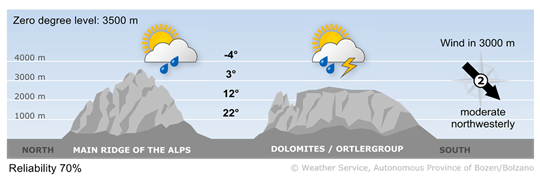
Temporarily changeable
In the mountains, the weather will be changeable, with a mix of sun and clouds. Showers, some of which may be thundery, are possible throughout the day.
upper wind
2 - moderate wind
16-30 km/h
3 - strong wind
31-60 km/h
4 - stormy wind
> 60 km/h
Mountain weather tomorrow

Sunny and stable mountain weather
In the mountains, sunshine will be widespread. Visibility will be excellent, with only a few harmless clouds.
upper wind
2 - moderate wind
16-30 km/h
3 - strong wind
31-60 km/h
4 - stormy wind
> 60 km/h